 FREE SHIPPING ON ORDERS OVER $30
FREE SHIPPING ON ORDERS OVER $30
 Sale!
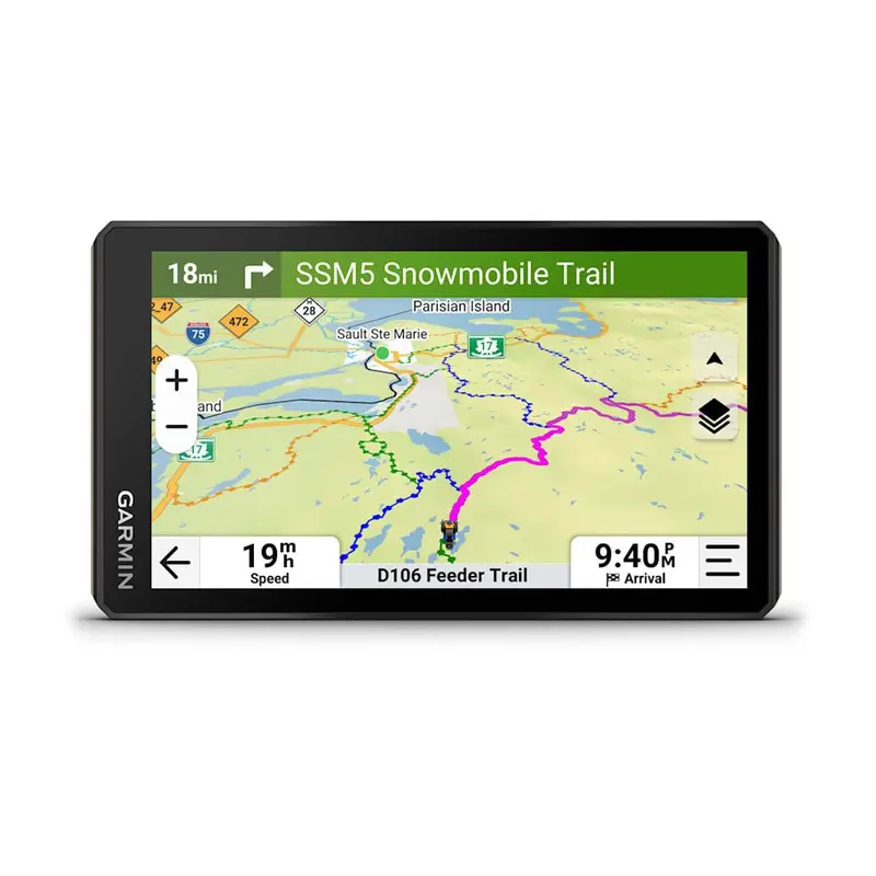
Sale! ROAM THE UNKNOWN ON DIRT AND SNOW This rugged powersport navigator will show you the way, with navigation for all the places you love to ride. In the Box: Tread 2 Tube mountkit Power cable USB cable Documentation RUGGED DESIGN The 6 high-resolution, ultrab
ROAM THE UNKNOWN ON DIRT AND SNOW
This rugged powersport navigator will show you the way, with navigation for all the places you love to ride.
In the Box:
RUGGED DESIGN
The 6 high-resolution, ultrabright and glove-friendly touchscreen navigator is purpose-built to withstand extreme temperatures and weather (IP67 dust/water rating) for rugged off-road adventures. The upgraded processor delivers faster performance, including map drawing and route calculations.
TURN-BY-TURN NAVIGATION
Get turn-by-turn trail navigation for unpaved roads and trails in off-road riding areas with OpenStreetMap, U.S. Forest Service Motor Vehicle Use Maps and Adventure Roads and Trails mapcontent1.View areas included throughout North America.
HANDLEBAR CONTROLLER
Get critical button control of your map, and keep your hands on the handlebars while riding, when paired with your wiredhandlebar controlleraccessory (sold separately).
SATELLITE VIEWS
Download subscription-free satellite imagery directly to the device via Wi-Fitechnology to see high-resolution overhead views of routes and terrain.
SNOWMOBILE TRAILS
View snowmobile trail content for select areas within the U.S. and Canadian provinces; includes snowmobile-accessible locations such as fuel stops, warming shelters, restaurants and more.View coverage areas in your state or province.
OUTDOOR MAPS+
Purchase anOutdoor Maps+subscription for ongoing access to premium map content, including slope angle, slope aspect, avalanche risk report and more.Learn moreabout the Outdoor Maps+ content available for Tread devices.
FIND NEW WAYS TO EXPLORE
NAVIGATION FEATURES
GROUP RIDE MOBILE
Track friends from your compatible smartphone or Tread device when you and your friends use theTreadapps group ride mobile feature.
SYNC YOUR DEVICES
Use the Tread mobile app to easily sync waypoints, tracks, routes and collections across your mobile device and Tread 2 navigator.
ABC SENSORS
For tough-terrain guidance, built-in sensors include an altimeter, barometer, compass and pitch/rollgauges.
KNOW YOUR BOUNDARIES
Access public land boundaries for national forests, Bureau of Land Management, wilderness areas and more. Also, see private land boundaries and landowner information for parcels greater than 4 acres.
SHARE YOUR FAVORITEROUTES
Easily send GPX files from your phone or third-party sources to your Tread 2 navigator. Share GPX files with fellow riders by using the Tread app on your compatible smartphone.
GO-ANYWHERE GUIDANCE
Get spoken turn-by-turn directions if you choose to take Tread 2 with you when you head back to civilization and want street navigation. This includes driver alerts for sharp curves, speed changes and more.
DOG TRACKING
Wirelessly pair Tread 2 with your compatibleGarmin GPS dog trackerto help track and retrieve your sporting dogs in the field. Youll see markers for each dog within tracking range, overlaid right on the navigators map screen.
LIVE WEATHER
Weather ahead? Pair Tread 2 with your compatible smartphone, and download the Tread app to access live weather, storm alerts, animated radar and more.
CAMPGROUNDS
Tread 2 comes with a preloaded directory of Ultimate Public Campgrounds to help you find more than 46,000 camping locations across the U.S.
TRAVELING MUSIC
A built-in media player lets you easily control music loaded on yourcompatible smartphoneon the navigators display and hear your tunes through your helmet or headset enabled with BLUETOOTHtechnology.
COMPATIBILITY FEATURES
INREACH TECHNOLOGY
Pair your Tread 2 powersport navigator with yourcompatible inReachglobal satellite communicator2for two-way text messaging, interactive SOS and weather.
MOUNTING OPTIONS
Tread 2 includes rugged roll tube and handlebar mount options to best fit the setup of your powersportvehicle.
GROUP RIDE RADIO
When you ride outside of cell coverage, pair Tread 2 with yourGroup Ride Radiofor location sharing with your group and voice communication using the included push-to-talk fist mic. Pair Tread with your helmet or headset enabled with BLUETOOTHtechnology for hands-free communication.
DIGITAL SWITCH BOX
Enable on-screen control for your vehicles 12-volt electronics including light bars, differential locks and more when paired with yourGarmin PowerSwitchdigital switch box. Not intended for controlling motors with reverse polarity.
1Limitations may exist in map data for some road and trail route suggestions. Always defer to all posted road signs and conditions during vehicle operation. Garmin products using OpenStreetMap data are intended to be used only as supplementary travel aids.
2Active satellite subscription required. Some jurisdictions regulate or prohibit the use of satellite communication devices. It is the responsibility of the user to know and follow all applicable laws in the jurisdictions where the device is intended to be used.
Satellite Imagery 2024 Maxar Technologies (date of satellite imagery may vary). OpenStreetMap is a trademark of the OpenStreetMap Foundation, and is used with their permission. This product is not endorsed by or affiliated with the OpenStreetMap Foundation. Wi-Fi is a registered trademark of the Wi-Fi Alliance. The Bluetooth word mark and logos are registered trademarks owned by Bluetooth SIG, Inc. and any use of such marks by Garmin is under license.
| General | |
|---|---|
| Dimension | 6.15″W x 3.5″H x 1″D (15.6 x 8.9 x 2.5 cm) |
| Weight |
12 oz (340g) |
| Water rating | IPX7 |
| Display Type | multi-touch, glass, high brightness HD color TFT with white backlight |
| Display Size | 5.3″W x 3.0″ H (13.3 x 7.5 cm); 6″ diag (15.3 cm) |
| Display resolution | 1280 x 720 pixels |
| Dual-orientation display | Yes |
| Tube mount (1.5″ – 2.375″) | Yes |
| Handlebar mount (up to 1″) | yes (smaller tube mount) |
| 1″ ball adapter with AMPS plate | Yes |
| Drop rating | MIL-STD-810 |
| Dust rating | IP6X |
| Battery Type | rechargeable lithium-ion |
| Battery life |
up to 7hours (up to 5 hours at 100% backlight) |
| Maps & Memory | |
|---|---|
| Preloaded street maps | Yes |
| High Definition 3D terrain | Yes |
| Data cards | microSD card (not included) |
| 3D Terrain | Yes |
| Internal storage | 64 GB |
| Ability to add maps | Yes |
| External memory storage | yes (256 GB max microSD card) |
| Includes map updates | Yes |
| Downloadable Satellite Imagery | Yes |
| TOPO map support | Yes |
| Downloadable USGS Quad Sheets | yes (Outdoor Maps+ Subscription) |
| Sensors | |
|---|---|
| GPS | Yes |
| Galileo | Yes |
| Barometric altimeter | Yes |
| Compass | Yes |
| 10 Hz multi-GNSS positioning | Yes |
| Outdoor Recreation | |
|---|---|
| Point-to-point navigation | Yes |
| Preloaded topographical maps | Yes |
| Preloaded US public land boundaries | Yes |
| Preloaded private land parcel maps | yes (parcels greater than 4 acres) |
| Preloaded USFS Roads and Trails, including motor-vehicle-use-maps for motorcycle, ATV, SXS and full-size 4×4 | Yes |
| Navigate-a-track navigation | Yes |
| Turn-by-turn trail navigation | Yes |
| Compatible with Outdoor Maps+ Subscription | Yes |
| Camera Features | |
|---|---|
| Backup camera compatible | yes (BC 50 only) |
| Navigation Features | |
|---|---|
| Garmin Real Directions landmark guidance | Yes |
| TripAdvisor Traveler Ratings | Yes |
| Route shaping through preferred cities/streets | Yes |
| Includes traffic | yes (with Garmin Tread app) |
| Lane assist with junction view (displays junction signs) | Yes |
| BLUETOOTH pairing | yes (works with BLUETOOTH-compatible helmet, headset or smartphone. BLE capable.) |
| Speed limit indicator (displays speed limit for most major roads in the U.S. and Europe) | Yes |
| Advanced Features | |
|---|---|
| Smart notifications via app | Yes |
| Wi-Fi map and software updates | Yes |
| Access to live services via app (traffic, weather, etc.) | Yes |
| Motorcycle Features | |
|---|---|
| Control music and media from smartphone or MP3 player | Yes |
| Sunlight readable and weather resistant | Yes |
| Garmin Adventurous Routing | Yes |
| Elevation profile | Yes |
| Round trip routing | Yes |
| Custom mapsupport | Yes |
| Wireless ANT+ technology | Yes |
| RV Features | |
|---|---|
| Specialized routing for the size and weight of your vehicle | yes |
| Speed limit changes | Yes |
| Easy Route Planner with GPX file sharing | Yes |
| Adventure Features | |
|---|---|
| Pair with compatible inReach devices | Yes |
| Pair with Garmin PowerSwitch digital switch box | Yes |
| Compatible with handlebar controller | Yes |
| Compatible with Group Ride Radio | Yes |
| Group Ride Mobile | yes (with Garmin Tread app) |
| Track recorder (breadcrumbs) | Yes |
| Compatible with the Garmin Tread app for route planning and data management (waypoints, tracks, and routes) | Yes |
| Ultimate Public Campgrounds | Yes |
| Pitch and Roll gauges | Yes |
| Glove-friendly touchscreen | Yes |
| Outdoor Applications | |
|---|---|
| Dog tracking | Yes |
Standard Shipping
Cost: $25
Free Shipping
We offer free shipping on orders over $30. Please check the free - shipping eligibility at checkout.
Delivery Time:
It usually takes [3-5] business days for standard shipping. Please note that this is an estimated time frame and may be affected by local holidays, and unforeseen circumstances.


Reviews
There are no reviews yet.